

Amnesty International yesterday released satellite images that show the impact of a horrific Boko Haram attackin northeast Nigeria last week. The images, combined with several testimonies, provide shocking evidence of how the conflict is dramatically escalating, with dire consequences for civilians.
Our analysis has generated some much-needed attention on a widely overlooked massacre, creating major stories on established and new media sites.
From Joseph Kony to SOS signs, satellite images can show a lot that is relevant for human rights investigations. And no, George Clooney was not the first to use them. Here is some background on the new analysis, and on the use of satellite images in human rights investigations.
What are the key findings?
- In the words of your researcher: “Of all Boko Haram assaults analyzed by Amnesty International, this is the largest and most destructive yet.”
- The scale of the destruction suggests a much higher death toll than given by the Nigerian government of 150 people. Some reports claimed that up to 2,000 people might have been killed in last weeks attack.
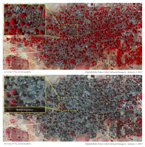
- Over 3,700 structures in the two neighboring towns Baga and Doron Baga were damaged or completely destroyed. The damage and destruction stems from fire.
The destruction is likely higher than visible in the current satellite images. It proved difficult to delineate and confirm individual structures in some densely packed areas and under tree canopies. Additionally, the current analysis only covered two towns—other towns and villages in the area might have been affected as well.
Why is a human rights group using satellite images in the first place?
The current case is a text book example of the added value of satellite imagery for human rights investigations: First, it gives us (remote) access to an area that is largely inaccessible to independent observers such as investigators and journalists. The images allow us to cut through the fog of war and help us establishing indisputable facts, such as a damage count and a timeline of events. Additionally, the images provide compelling visual evidence that allow us to shine a much-needed light on an overlooked crisis.
How are the images analyzed and interpreted?
In this case, the analysis is very straightforward: Two images from 2 January and 7 January, 2015, provide a before and after image, respectively, of the attack. Analysts can do a simple “change detection” analysis to determine the changes over the observation period, including the exact number of structures destroyed or damaged. Additionally, in the current case, analysts used a technique called false color image analysis to better track the destruction caused by fire on houses and vegetation. In false color imagery, healthy vegetation appears bright red (we used the same methodology to document oil spills in the Niger Delta, which helped to achieve an important victory recently when Shell paid out a long-overdue compensation to the victims). As can be seen in the two different images, the difference is quite striking, with the fire damage apparent in the after image from 7 January.
How do you get the imagery and analysis?
We are relying on commercial satellite image providers such as DigitalGlobe or Astrium to get imagery. Similar to working with forensic or weapons experts, we are working with satellite imagery analysts to provide relevant facts. Amnesty International experts use the analysts’ findings to integrate with our traditional fact-finding work, e.g. testimonies, and evaluate them in relation to applicable international human rights, refugee or humanitarian law.
Was George Clooney the first to use satellites?
No. The Committee for Human Rights in North Korea used satellite images to analyze political prison camps in North Korea as early as 2003. In 2004, Amnesty International (Denmark) tested the use of low-resolution imagery to document violations in Darfur, Sudan. Since then, Amnesty International has used satellite imagery in dozens of research project, and since 2007 has dedicated staff to facilitate satellite image analysis.
What else can satellite images show that is relevant for human rights investigations?
- People fleeing conflict zones
- Mass graves
- SOS signs
- Joseph Kony
- Secret or unofficial detention facilities
- Housing demolitions
- The consequences of corporate negligence, such as oil spills or gas flaring
- Military deployments, weaponry and roadblocks
- Damage to or destruction of cultural heritage sites